
Dear colleagues,
first of all, I wish you an excellent 2020 for you and our Working Group!
We believe it is extremely important to create a common database to have an adequate tool to facilitate the exchange of macroseismic information and to compare the data of each group with each other. For this reason, we propose a test of the new graphical tool that we prepared to display macroseismic information on the map (see below how to upload your data for doing this test). A draft, incomplete version is available at the address (sorry, now only in Italian, but Google Translate does the translation pretty well):
http://eventi.haisentitoilterremoto.it/q2.html
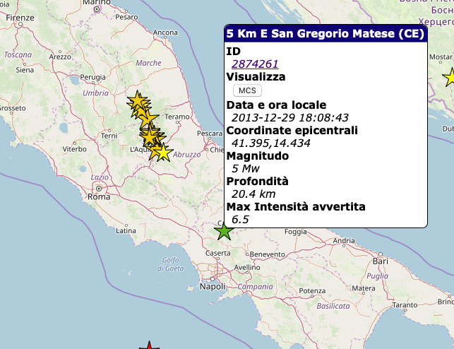
For example: Select with a click the earthquake represented by the green star in Central Italy, between the city of Caserta and Campobasso.

After the click this panel will open:
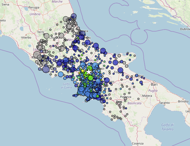
Click on the MCS button and the map of macroseismic intensities of such seismic event will appear:
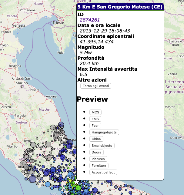
If you click again on the epicenter star (now it is white) a new panel will appear with the buttons of the individual effects:
Select one of the effects and the distribution of observation percentage will appear on the map:
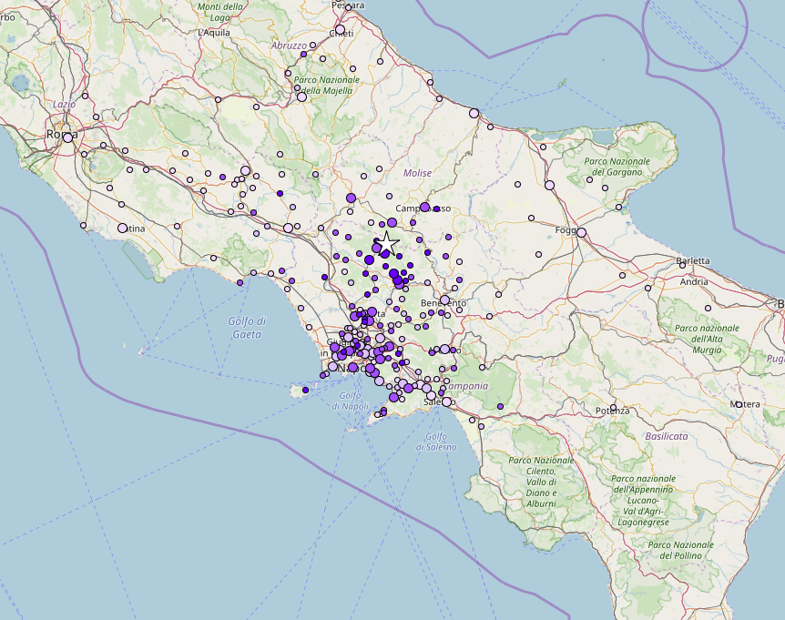
This map shows the distribution of the percentage of citizens who experienced fear during the earthquake: the diameter of the circles indicates the number of responses for that town, the colour represents the percentage of frightened citizens (the more intense the colour, the higher the percentage). Our intent is to propose a tool to visualize the data that will be shared, first of all, the macroseismic intensity points and, for those who can supply it, also data of single effects. We encourage you to try it in this beta version and give us comments and suggestions.
Your contribution
To test the sharing of the data, we ask you to send us the macroseismic data of one (or more) of your earthquakes, following the format that we propose below. If you have any comment and/or suggestions on the format, please let us know. After this phase, we will ask, to who will be able to supply them, data about single effects.
We thank you for your cooperation,
Valerio De Rubeis, Patrizia Tosi and Paola Sbarra
_________________________
Structure of macroseismic database files
The database will be composed of two main sections (file): one for earthquakes and the other one for intensity points pertaining to the provided earthquakes.
Earthquake file:
Export a .csv file with all earthquakes (one row=one earthquake) that you want to provide for this exercise and name it as:
YOURINSTITUTE_eqs.csv (e.g. INGV_eqs.csv, ROB_eqs.csv….)
Please order the .csv file structure as follows:
Id(e),Time,Lat,Lon,Depth,Mag,MagKind
Id(e) = univocal identification code of seismic event
Time = UTC time in ISO 8601 international standard (https://en.wikipedia.org/wiki/ISO_8601)
Lat =latitude
Lon =longitude
Depth =depth in km
Mag =magnitude
MagKind= ML, Md,Mw,……..
Note:
* if more than one magnitude is provided for the same seismic event, please add them in new columns, specifying for each one the magnitude type.
* For time format refer to https://en.wikipedia.org/wiki/ISO_8601.
Example: first two rows of an INSTITUTE_eqs.csv file (label row and data row):
Id(e),UTC_Time,Lat,Lon,Depth,Mag,Magkind
3244,2020-01-16T12:25:37Z,12.693,42.379,12.4,4.8,ML
Intensity file:
Export a .csv file for each earthquake listed into the previous file (INSTITUTE_eqs.csv earthquake section), with the intensity information for all localities (one row=one locality).
Please name each file as
YOURINSTITUTE_id(e)_int.csv (e.g. INGV_3244_int.csv, INGV_1579_int.csv……)
Please order the .csv intensity file as follows: Id(e),Lat,Lon,Loc,LocKind,Int,IntKind,NumQuest
Id(e) =univocal identification code of seismic event
Lat =locality latitude
Lon =locality longitude
Loc =locality name
LocKind= locality kind (town, village……)
Int = macroseismic intensity
IntKind=macroseismic scale: MCS, EMS, MMI, ….
NumQuest= number of questionnaires used for that specific locality